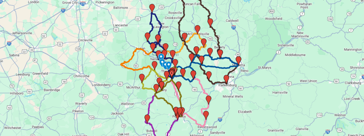
I’ve created a custom Google Maps route for the Ohio Windy 9 – a series of scenic motorcycle and driving routes through southeastern Ohio known for their winding roads and beautiful countryside. Since I couldn’t find an existing comprehensive map online, I decided to piece it together myself. This map is meant as a general reference to help others plan their ride; please note that a few markers or paths may not be perfectly aligned with the official Windy 9 routes (as the google maps allow only 10 points), but they should still give you a solid overview of each ride. Ride safe and enjoy the curves!
Rim of the World (State Route 78)
Up, up, and away to the top of Ohio’s Windy 9. Gaze upon the “Rim of the World” along the famous Route 78. Wayne National Forest, Burr Oak State Park, and the Stockport Mill highlight one of America’s most popular rides!
https://maps.app.goo.gl/J4uCQExBjPZf8uoz7
2 Hours / 86.6 miles
Southern Dip
Head south along the Ohio River Scenic Byway through river towns of yesteryear. At the southern most point of this loop you can cross the mighty Ohio to visit Point Pleasant, West Virginia — spot the “Mothman.” Or stay on our side of the river and take a break at the Gallipolis City Park before turning north for more scenic Appalachian countryside.
https://maps.app.goo.gl/3ELVL2boVXMrHJWz8
2 Hours / 92.8 miles
Hocking Hills Nipper
Onward through Wayne National Forest into the famous Hocking Hills region to discover one of America’s most popular eco-adventure destinations. Take your time along the Hocking Hills Scenic Byway and explore a variety of unique, seasonal experience.
https://maps.app.goo.gl/pVpntqzNev6oybsa8
2:15 hours / 90 Miles
Lazy Rivers
Cruise alongside the Hocking River to its confluence with the Ohio. See some great modern engineering as you pass many Ohio River locks and dams. Visit the biker-friendly town of Pomeroy,featuring region’s best views of the Ohio River.
https://maps.app.goo.gl/h9QzxkSPAYBjLYqB7
2:30 Hours / 101.1 miles
Zaleski Zipper
Get a perfect snapshot of the true Ohio riding experience on this short route. Zip though the curvy roads or take it slow. Explore Lake Hope State Park, Zaleski State Forest, or navigate the gravel road to the popular Moonville Tunnel.
https://maps.app.goo.gl/mYqfguJ3JruZjxCi6
1:15 Hours / 60.8 miles
Pioneer Pass
Majestic rolling hills are showcased along this challenging trek. You’ll get a glimpse of State Route 555, aka The Triple Nickel, as you breeze by ridge top farms and orchards on your way to and from the rivertown of Marietta, Ohio.
https://maps.app.goo.gl/M8QpBfU5Dp7H85bH6
2:30 Hours / 103.5 miles
Pomeroy Dash
Old US 33 takes riders back in time by navigating the main historic thoroughfare connecting Athens to the Ohio River. Fill the belly and the bike in Pomeroy before heading deep into Ohio’s Appalachian backcountry.
https://maps.app.goo.gl/VW2yq5teuGhF7mvZ7
1:30 hours / 63.3 miles
Black Diamond Run
Celebrate the Hocking Valley’s coal heritage with a tour through the Little Cities of Black Diamonds. Turn-of-the-century upstart mining towns shimmer along this jewel of a ride. Toss in the Wayne National Forest and Nelsonville’s Historic Square for a most unforgettable run.
https://maps.app.goo.gl/c4xxkKfZxTksQaQY6
2.5 Hours / 100 Miles
The Triple Nickel (State Route 555)
Test your skills on OH 555, also known as The Triple Nickel. Considered the most technically challenging road in the region, this ride is not for beginners. For the rest of you, get ready for one of the best rides of your life.
https://maps.app.goo.gl/Xfi4duovbUcfRS6UA
3.5 Hours / 148 Miles
All 9 roads are plotted on one map
https://www.google.com/maps/d/u/0/edit?mid=104xBpInaaIF2CDsLgldq4yDhPlkjHb8&usp=sharing
Text and maps copied from: https://www.windy9.com/